


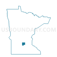
Glencoe P-3, McLeod County, Minnesota
About
Outline

Summary
| Unique Area Identifier | 602989 |
| Name | Glencoe P-3 |
| County | McLeod County |
| State | Minnesota |
| Area (square miles) | 0.74 |
| Land Area (square miles) | 0.74 |
| Water Area (square miles) | 0.00 |
| % of Land Area | 99.94 |
| % of Water Area | 0.06 |
| Latitude of the Internal Point | 44.77623820 |
| Longtitude of the Internal Point | -94.13911340 |
Maps


Graphs
Select a template below for downloading or customizing gragh for Glencoe P-3, McLeod County, Minnesota


Neighbors
Neighoring Voting District (by Name) Neighboring Voting District on the Map
- Glencoe P-1, McLeod County, MN
- Glencoe P-2, McLeod County, MN
- Glencoe P-4, McLeod County, MN
- Glencoe Twp. Voting District, McLeod County, MN
- Helen Twp. Voting District, McLeod County, MN
Top 10 Neighboring County Subdivision (by Population) Neighboring County Subdivision on the Map
- Glencoe city, McLeod County, MN (5,631)
- Helen township, McLeod County, MN (863)
- Glencoe township, McLeod County, MN (495)